Saturday 12 October 2019

YAMUNOTRI

Situated amidst the Garhwal Himalayas, Yamunotri in the state of Uttarakhand is naturally bestowed with abundant beauty and charm. At a hovering altitude of 3293 meters, Yamunotri lies adjacent to the Indo-Chinese border and is encircled by the lofty peaks on all sides. One of the holiest centers in the Hindu pantheon, this sacred abode of the Asti muni boast of so many unparallel vistas of nature.
Highly revered as the origin of the majestic River Yamuna, Yamunotri is famed for its glaciers, and thermal springs that makes it one of the most important stopovers in the schedule of a Hindu pilgrim. According to Hindu tradition, Yamuna is the sister of Yama, the god of death and a holy dip in this river secures a painless death to the devotee
A thrilling and exhilarating location in the footsteps of Garhwal mountain ranges, Yamunotri proffers picturesque surroundings with the awesome shrubs, lush meadows and gushing cascades. A legendary place, which demands lots of courage and stamina to reach, Yamunotri would be a perfect place for those who love escapades. The trek to Yamunotri is magnificent, subjugated by mind stilling views of craggy peaks and intense forests.
From the snow-clad summits to the turquoise lakes, Yamunotri has unbelievably romantic allures on store for those who are young at heart. Its imposing walking trails beside the gushing streams presents some of the spectacular moments that one could never forget.

Perched at an altitude of 3293 meters above sea level, Yamunotri is located in the Uttarkashi district of the northern state of Uttar Pradesh. It is very close to the Indo-Chinese border and is surrounded by the Himalayan offshoots on all sides. Yamunotri, lies near the Bandarpunch Mountain, which is 6315 m high and lies to the north. The glacial lake of Saptarishi Kund, on the Kalind Parbat, at an altitude of 4421 m, is the real source of the Yamuna River. Yamunotri is at a distance of 278 km from Dehradun, 236 km from Rishikesh, 176 km from Chamba, and 21 km from Sanya Chatti. 

Best Time To Visit

It remains cool even during summers. The winters are snow-bound and temperatures fall below 0°C. One is advised to carry light or heavy woolens depending on the time of visit.

GANGOTRI

Gangotri Dham, located at the height of 3,100 meters (approx.) on the Himalayan range in Uttarkashi district of Uttarakhand, holds a very special place in the hearts of Hindus. It is one of the four sacred and important pilgrimage sites of Chota Char Dham Yatra in Uttarakhand. Amid all the natural beauty and grace which the mountains and altitude of the place affords, what makes Gangotri one of the holiest places is its intimate connection with River Ganga (the Ganges).
Ganga Maa (mother), the much revered deity of Hindus, originates from the Gangotri glacier at Gaumukh which is some 18 km from the Gangotri town. It is said that Goddess Ganga came to earth in order to wash away the sins of King Bhagirathi's ancestors. From the folds of mythology till the present time, Ganga River has always been a sacred source of purity for the mankind. Coming to Gangotri for a religious tour is not only a religious duty but a spiritual calling too.

PENANCE OF BHAGIRATH

Going by the legends, it is said that King Sagara, the great grandfather of King Bhagirath slayed the demons on earth. In order to proclaim his supremacy, he decided to stage an Ashwamedha Yagna. During the yagna , a horse was supposed to be let loose to go on an uninterrupted journey across empires. In the course of events, Indra the supreme ruler feared that he might be deprived of his celestial throne if at all the yagna got complete. Using his celestial powers, he took away the horse and privately tied it in the ashram of Sage Kapila, who was seated in deep meditation.
As soon as King Sagara's agents realized that they had lost track of the horse, King allotted his 60,000 sons the task of tracing the horse. While the king's sons were on a hunt for the lost horse, they came across the spot where Sage Kapila was meditating. They found the horse tied next to him, out of fierce anger they stormed the ashram and accused the sage for stealing the hoarse. Sage Kapila's meditation got disrupted and out of fury he turned all the 60,000 sons into ashes just with his powerful glance. He also cursed that their souls would attain Moksha, only if their ashes get washed by the holy waters of River Ganga, which was then a river, seated in heaven. It is said that Bhagirath, the grandson of King Sagara in order to free his ancestors performed rigorous penance for a 1000 long years to please Ganga to come down to the earth. Finally his efforts bore fruit and River Ganga was pleased by his devotion and was ready to descend to earth.

TALE OF RIVER GANGA

Another legendary tale states that when River Ganga agreed to descend to earth in response to Bhagirath's prayers, its intensity was such that the entire earth would have got submerged under its waters. To save the planet earth from such demolition, Lord Shiva caught River Ganga in his locks. To please Lord Shiva, Bhagirath again meditated for a very long time. On seeing Bhagirath's immense devotion, Lord Shiva being pleased released River Ganga in the form of three streams one of which came on earth and came to be known as the Bhagirathi River. As soon as Ganga's water touched the ashes of the Bhagirath's ancestors, the 60,000 sons rose from eternal rest. The stone on which Bhagirath is believed to have meditated is known as the Bhagirath Shila which is located fairly close to the Gangotri Temple.

GAUMUKH AND TAPOVAN

To witness the holy birth of River Ganges at Gaumukh, one can take up a picturesque and exciting trek surrounded with peaks and soaring peaks. One can further trek to Tapovan which is about 4 km from Gaumukh. Tapovan has meadows, beautiful flowers, streams and incredible views of surrounding Himalayan Peaks such as Shivling and Bhagirathi. Tapovan is also a base camp initiating a number of mountaineering tours.

KEDARNATH

Kedarnath Dham, located in the Rudraprayag district of Uttarakhand, is one of the most paramount locations for worshipers of Shiva. The air appears to be reverberating with the name of Lord Shiva amid the mighty snow-clad peaks, enchanting meadows and forests of the lower mountain range of Himalayas. Situated in a breathtaking location, near the source of Mandakini River and at the height of 3,584 meters, Kedarnath Dham celebrates the greatness of Lord Shiva. Kedarnath temple is one of the 12 Jyotir Lingams and is also the most important temple among the Panch Kedars (group of 5 Shiva temples in Garhwal Himalayas). It is also one of the significant temples of the sacred Chota Char Dham Yatra in Uttarakhand, raising the glory of the place to further heights.
Accessible from major destinations of Uttarakhand, the motorable road towards Kedarnath temple stretches till Gauri Kund. After that one needs to take a 14 km trek towards Kedarnath temple. Ponies and palanquins (doli) are easily available; one can also avail helicopter services during peak season of yatra.


The hard journey till the great shrine of Shiva is well compensated with the spiritual atmosphere which is created by the unruffled, tranquil and splendid beauty of the region. The majestic Kedarnath peak (6,940 meters) stands behind the temple along with other peaks, forming a perfect setting for the holy land of the supreme deity. The conical-shaped Shiva lingam in the Kedarnath temple is a unique feature of the temple among all Shiva shrines.

LEGEND BEHIND THE KEDARNATH TEMPLE

Burdened with the guilt of killing their blood relatives, Pandavas sought Lord Shiva to absolve themselves of their sins. Shiva didn't want to release them from their wrongdoings so easily and disguised himself as a bull to roam in Garhwal Himalayas. On being discovered by Pandavas, Shiva dived into the ground. Bhim tried to catch him and could only get hold of the hump. Other body parts of Shiva (in the form of bull), came up at different places. Hump of the bull was found in Kedarnath, navel emerged at Madhya-Maheshwar, two forelegs appeared at Tunganath, face in Rudranath, and hair came up at Kalpeshwar. Together these five sacred places are called Panch Kedar. It is believed that originally Pandavas built the temple of Kedarnath; the present temple was established by Adi Shankaracharya who restored and revived the glory of the shrine.

Friday 24 March 2017

LANSDOWNE

Lansdowne

History
Originally known as Kaludanda (Hindi: कालूडाण्डा) after Kalu (Black) and Danda (Hill) in Garhwali, Lansdowne was founded and named after then Viceroy of India (1888-1894), Lord Lansdowne in 1887, and by 1901 it had a population of 3943.[1] Lansdowne was developed by the British for catering for the Recruits Training center of the Garhwal Rifles. Lansdowne was a major place of the activities of freedom fighters from British Garhwal during British period. Nowadays, the famous Garhwal Rifles of the Indian Army has its command office here.[2] Lansdowne is one of the quietest hill stations of India and is popular since Britishers came to India. Lansdowne is unlike other hill stations as it is well connected with motorable roads but remote in its own way. It is situated at an altitude of 1,706 mts above sea level surrounded with thick oak and blue pine forests in the Pauri Garhwal district of Uttarakhand state.

On 5 November 1887, the first battalion of Garhwal Rifles migrated from Almora to Lansdowne. Lansdowne was the only city after Almora in the late 1870s. People of different culture and states came to do business in Lansdowne after it became popular. The buildings and church of Lansdowne built during British period, which dates back to the pre-independence period. Lansdowne is an ideal location for eco-tourism as it is well preserved by the Government of Uttarakhand and the Garhwal Rifles.

Local attractions
The War Memorial, at the Parade Ground of the Garhwal Rifles Center, is an attraction for the visitors. However, prior permission from the military authority has to be taken. Places of interest around the city include Tip n Top View Point, Kaleshwar Mahadev Temple, which is the most visited Hindu Temple in Lansdowne and is flocked by thousands of devotees during the month of Sawan ( Indian Monsoon ), Santoshi Mata Temple, Regimental Museum (also called the Darwan Singh Sanghralaya), Bhullatal Lake, St. Mary's Church, and Lover's lane. The excursions from the city are Tarkeshwar Mahadev Temple, Bhairav Garhi Temple, Bhim Pakora. The Annual ‘Sharadotsava’ (Festival of Autumn) is also organized at this hill station during autumn season. The old cemetery in Kitchner Lines is one of the more mysterious places and some even call it one of the most haunted places in lansdowne. Many war veterans have been laid to rest in the old cemetery and the graves are as old as 150 years.

The Garhwal Rifles regimental museum, also called Darwan Singh Sanghralaya, houses artefacts from the beginning of the Regiment. The Garhwal Rifles participated in the two world wars among countless other battles throughout its more than 100 years of history. All artifacts, including photographs, arms used by regimental commanders, captured weapons, campaign history and other information is displayed in this museum. There are many items, such as medals won by erstwhile Garhwal Rifle soldiers, that have been put on display, this includes the Victoria Cross awarded to Darwan Singh Negi and Gabar Singh Negi.[citation needed] Lansdowne is also famous for standard education.

How to reach Lansdowne
It is the nearest hill station from Delhi and can be reached from Delhi by either road or train. The nearest railway station is Kotdwar at a distance of 44 km situated an elevation of only 370 m. Since Lansdowne is more than 1,300 m higher than Kotdwara, the drive from Kotdwara to Lansdowne is quite steep and scenic. The nearest airport is Jolly Grant Airport, near Dehradun at a distance of 152 km via Kotdwar-Haridwar road. The other and better route to reach Lansdowne is from Delhi via Meerut, Bijnore, Najibabad, Kotdwar and on to Lansdowne. It saves about 50 km and the road quality is also good all the way to Kotdwar. One has to take a right turn from NH-119 at a place where The Garhwal Rifles has put a huge signboard by painting the directions on rocks. Lansdowne is 81 km from Pauri and about 250 km from Delhi. The drive through Blue Pine trees on hills near Lansdowne is a wonderful experience.


Sunday 3 July 2016

MUSSOORIE

Mussoorie is a hill station and a municipal board in the

 Dehradun District of the northern Indian state of 

 Uttarakhand. It is located about 35 km from the state capital

 of Dehradun and 290 km north from the national capital of

 New Delhi.


               Tourism is the most significant segment of Mussoorie's economy. It has a nature walk known as "Camel's Back Road". This road takes its name from a rocky outcrop in the shape of a camel's hump. Along the road, a cemetery is located about mid-way on the loop. There is also "Gun Hill" where a cannon was used to sound out midday for many years. Gun Hill is accessible by the cable car on the Mall road. The oldest Christian church in the Himalayas, St Mary's, is situated above Mall Road, and is currently undergoing restoration. Kempty Falls is a nice picnic spot. Company Garden is popular tourist destination. During season, the Company Garden has a vast collection of flowers and plants. Happy Vally has a small Tibetan temple. This was the first Tibetan temple built in India. The temple was constructed in 1960 by the Tibetan refugees. Lal Tibba is another tourist spot of Mussoorie. PicturesqueDhnaulti hill station is about 32 kilometres from Mussoorie. Mussoorie also had India's largest roller skating rink.
Nahata Estate Previously known as "Childer's Lodge" is a huge property of more than 300 acres, owned by the Harakh chand nahata family. It is the highest peak of Mussoorie near Lal Tibba, it is situated at 5 km from the Tourist Office and one can go on horse back or on foot. The view of snow-clad mountains is exhilarating.
GunHill Second highest point of Mussoorie, at an altitude of 2024m located at30.4953°N 78.0745°E
Kempty Fall The Kempty Falls are situated on the hilly tracks of Uttarakhand, India, 15 km from Mussoorie on the Chakrata Road. This place is located nearly 1364 meters above sea level at 78°-02’East longitude and 30° -29’North latitude.
Lake Mist About 5 km before Kempty Falls on the Mussoorie-Kempty road is a good picnic spot with accommodation and restaurant facilities; boating is also available. With the Kempty river flowing through it, Lake Mist has many small waterfalls made by the river.

Municipal Garden Is a picnic spot having a garden and an artificial mini lake with paddle boating facility. It is located at a distance of 4 km by rickshaw cycles, pony or by a car and 2 km via Waverly Convent School road on foot.
Mussoorie Lake A newly developed picnic spot build by City Board & Mussoorie Dehradun Development Authority, is situated at 6 km on Mussoorie-Dehradun road having a facility of pedaled boats. It offers a view of Doon Valley and nearby villages.

A honeymooning couple find some romantic moments on top of Gunhill, Mussourie
Bhatta Falls 7 km from Mussoorie on Mussoorie-Dehradun Road near Bhatta Village. Accessible by car or bus up to Bhatta from where the fall is 3 km by foot. A fall with different ponds for bathing and water amusements, an ideal place for a picnic.
Jharipani Fall Located at 8.5 km from Mussoorie on Mussoorie-Jharipani road. One can go by local bus or car up to Jharipani from where the fall is about 1.5 km on foot.
Mossy Fall The fall is surrounded by a dense forest and is 7 km from Mussoorie. One can go there via Barlowganj or Balahisar.
Sir George Everest's House Park Estate is where one can find the remains of the building and laboratory of Sir George Everest, the Surveyor generel of India from 1830 to 1843. It is after George Everest that the world's highest peak Mt. Everest is named.[4] It is 6 km from Gandhi Chowk / Library Bazaar and is accessible by vehicle, although the road is very rough beyond Haathi Paon. The place provides a view of Doon Valley on one side and a panoramic view of the Aglar River valley and the snow peaks of the Himalayan ranges on the other. It is a scenic walk from Library Bazaar, and a picnic spot.
Nag Devta Temple An ancient temple dedicated to Snake God Lord Shiva and is situated on Cart Mackenzie Road about 6 km from Mussoorie on the way to Dehradun. Vehicles can go right up to the temple. This place provides an enchanting view of Mussoorie and the Doon Valley.

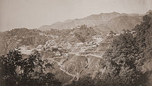
Mussoorie and Landaur, 1860s
Jwalaji Temple (Benog Hill) Situated at an altitude of 2240 m, this temple is 9 km west of Mussoorie. It is situated on the top of Benog Tibba (Hill) and contains an old idol of Goddess Durga. There is a view of the Aglar River valley. It cannot be accessed by vehicle although a motor road goes most of the way from Mussoorie.
Cloud End This hotel is surrounded by thick deodar forest. The bungalow, built in 1838 by a British major, was one of the first four buildings of Mussoorie and has now been converted into a hotel. The place provides peace and calm and is full of flora and fauna.
Van Chetna Kendra 11 km to the South of library point lies an old sanctuary established in 1993 and covering an area of 339 hectares. It is famous for the extinct bird species Mountain Quail (Pahari Bater), which was last spotted in 1876.

Mussoorie is a popular destination for honeymooning couples, mainly because of its relatively cool climes and calm and lovely environment.


LEH-LADAK

Ladakh is a region in Indian state of Jammu and Kashmir that currently extends from the Kunlun mountain range to the main Great Himalayas to the south, inhabited by people of Indo-Aryan and Tibetan descent.
District Leh is situated roughly between 32 to 36 degree north Latitude and 75 to 80 degree East longitude and altitude ranging from 2300 mtrs to 5000 mtrs above sea level. District Leh with and area of 45100 Sq. Kms. makes it one of the largest District in the country.The District is bounded by Pakistan occupied Kashmir in the west and China in the North and eastern part and Lahul Spiti of Himachal Pardesh in the south east. It is at a distance of 434 Kms from State capital ( Summer) Srinagar and 474 Kms from Manali (HP).

Topographically, the whole of the district is mountainous with three parallel ranges of the Himalayas, the Zanskar, the Ladakh and the Karakoram. Between these ranges, the Shayok, Indus and Zanskar rivers flow and most of the population lives in valleys of these rivers.